A warning on misleading ‘hotspot’ images
 A warning on misleading ‘hotspot’ images
I am writing to share a concern about the public use of hotspot information with limited accuracy due to lack of on-ground verification. In addition, snapshot images taken from hotspot visualised websites and sharing them on social media platforms without a technical explanation can unintentionally misinform the public and create a misleading perception of the actual situation.
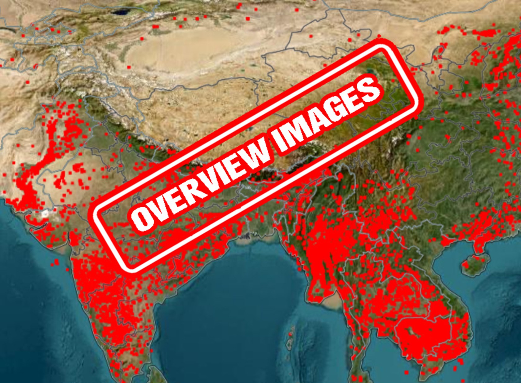
The Satellite-derived active fire/thermal anomalies, often visualised as “hotspots” at approximately 375m to 1km resolution using VIIRS and MODIS are valuable tools for rapid observation. These datasets are designed to capture conditions quickly, often in real time and are useful for initial detection and situational awareness. However, when interpreted over the large areas and at a global scale, their accuracy is inherently limited, and they are not intended to represent the full physical reality of on-ground hotspot conditions. Therefore, proper accuracy assessment is necessary, and presenting such data solely as snapshot images without adequate technical explanation can lead to misunderstanding.
Snapshot images from hotspot visualised websites on a nationwide scale tend to oversimplify complex conditions, as they provided limited spatial detail and average information over larger areas. As result, hotspots often appear as larger dots, clusters nearby hotspots, peak intensity symbols and overlapping features, creating the impression that they cover a wider area than they actually do. These visual effects are frequently blurred and not accurately represent the real on-ground situation of hotspots.
This can significantly affect public perception. Viewers may believe a hotspot is more widespread or more severe than it truly is, or they may misinterpret its origin and behaviour. When these images are shared without technical explanation, they can create a false sense of certainty, replacing measured reality with a visual approximation.
When hotspot information with limited accuracy or snapshot images of hotspot taken from visualised websites are circulated through media or social platforms without context, they risk fuelling confusion, fear or inaccurate conclusions. The public deserves transparency, especially when images are used to inform discussion, response or policy. Visual clarity should never be mistaken for scientific accuracy.
This letter is not a criticism of using the limited accuracy of hotspot information or snapshot imaging, but a call for responsibility in communication. Clearly labelling images and explaining their limitations would greatly improve public understanding and trust.
The Ministry of Environment updates and publishes hotspot information on a daily basis. For official and reliable data with assessed accuracy, please refer to the ministry’s social media platforms.
Accurate communication is essential when translating technical observations into public information.
Khvay Atitya is spokesperson for the Ministry of Environment. The views and opinions expressed are his own.
Phnom Penh Post